Ideas Forum
A place to share your ideas, join the chat and get more indepth info and data.
Cambridge Connections is the transport plan Waipā District Council is developing to guide our town's transport network over the coming 30 years.
Cambridge and the Waipā District is experiencing unprecedented growth. For many local residents, the population of Cambridge will more than double in their lifetime: projections show that by 2055, it will have grown to 33,000.
Transport infrastructure is vital to planning for growth – it affects all the ways people and goods move around the region, including roads, footpaths, cycleways, public transport, parking, freight, and the connections between them.
If we don’t plan well, we risk congested roads and a town that is difficult to get around. But with careful planning we can choose what forms of transport we use, ensure public spaces are centred around people, and prioritise climate resilience.
Here are two key reasons why we need to a develop a transport plan that will serve our community now and into the future.
As Cambridge residents, we already know this is a great place to live. Our town is full of character and green spaces, with thriving businesses and a vibrant town centre. It’s liveable and easy to get out and about.
Central Government has designated Waipā as a Tier One growth district – this means we’re required to plan for 30 years’ of housing and infrastructure. In other words, we need to grow! It’s important to plan carefully so Cambridge and Waipā continue to be a great place to live for future generations.
We need to plan for effective transport into the future, but crucially, we also need to be able to fund it. That is why we need to make a business case to New Zealand Transport Agency (Waka Kotahi).
In line with its 30-year plan, NZTA allocates funding on a three-year cycle:
Cambridge Connections will enable us to seek funding from NZTA, based on the recommendations the Council develops over the next 16 months – including:
When we asked the community for feedback about the future of transport in Cambridge, 58 percent of respondents said they want a 'third bridge', the most common theme to emerge.
Investigating bridge options will be an important aspect in planning for transport infrastructure over the next 30 years.
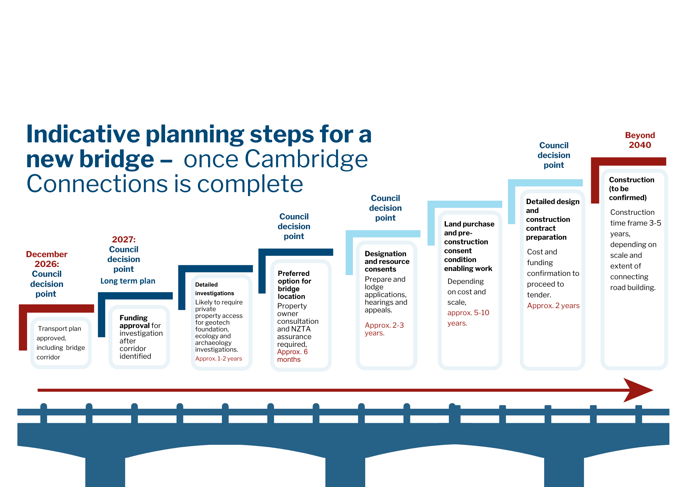
Cambridge Connections: Identifying a bridge corridor
At the end of next year, Cambridge Connections will have identified a bridge corridor, the general area where a new bridge and connecting roads could be built in the future. It will still be another two to three years before the specific site can be confirmed, due to the large amount of technical work required to meet legislative requirements. The potential bridge is a long-term project that will span decades. The steps ahead include:
Beyond Cambridge Connections:
We need to know what the transport problems are, in order to create the best solutions.
Defining the core transport problems Cambridge is facing is the first step in building a business case for NZ Transport Agency Waka Kotahi.
Elected Members approved these problem statements on Wednesday, December 3, meaning that stage one of Cambridge Connections is now complete!
These are the problem statements approved by Elected Members:
Rapid population and economic growth and development in and around Cambridge, coupled with high reliance on private vehicles and limited transport choices, is placing increasing pressure on the town’s transport network and wider network connections. This is increasing congestion, delays and safety risks, increasing emissions and negatively impacting on accessibility for the community.
Reliance on a small number of key connections, including only one bridge able to carry heavy traffic over the Waikato River in Cambridge, means all heavy and through traffic travelling east–west or north–south must pass through residential areas and the town centre. This increases crash risk for road users, increasing congestion, and diminishing the town’s amenity and character.
The ageing and limited capacity of bridge infrastructure, exacerbated by the lack of schools and essential services on the Leamington side of town is constraining reliable and resilient transport links between Cambridge and Leamington and the wider network. These limitations reduce network resilience, disrupt connectivity during emergencies and temporary closures, and compromise the safety and efficiency of the transport system.
By the end of 2026, Cambridge Connections will have been through the process of reviewing different potential locations for a bridge and will have identified a general area where a bridge could be constructed (known as a ‘bridge corridor’).
From 2027, there will be a large amount of technical studies needed to make sure we understand all the ecological, archaeological, and geotechnical elements, This could affect the reality of the impact of the bridge, how long the bridge will take to build and how much it will cost. These technical studies are also needed by law.
Once all of this work has been completed, there will be a “preferred location”, and it will then take another two or three years before land could be designated and protected - to make sure that we will be able to build the bridge in the preferred location. After land designation, there are still years of work to complete.
Land designation is a process laid out in the Resource Management Act 1991. It allows "requiring authorities" (local government, central government, and utility operators), to set aside land for specific public works or projects, such as roads, schools and hospitals. Once land has been designated, it is protected and cannot be developed in a way that would prevent or hinder the proposed work. The designation process is unlikely to change significantly in the upcoming resource management reforms. Designations in our district are listed in the Waipā District Plan.
Once land has been designated for a project, the requiring authority can begin the process of purchasing the land. Home and land owners receive the value of their property at its market value as if the land had not been designated for public use. An independent valuer determines what the property would sell for in an open market between “a willing seller and willing buyer”.
The full indicative timeframe is set out here:
Explore the progress we’ve made so far and what’s coming next in this project.
We asked for your help to solve Cambridge’s transport problems.
As the town grows, we wanted to know:
We received 1522 short, medium, and long term suggestions from 578 pieces of feedback, collected over a six-week consultation period.
Your ideas were sorted into themed transport categories as we began identifying which ideas might solve Cambridge’s transport problems. The themes are:
We ran your ideas through the NZTA Intervention Hierarchy, adding technical ideas and previous ideas to your ideas, to help find solutions. The hierarchy promotes low-cost, quick to deliver investment above costly infrastructure that takes time to build. This work is necessary before NZTA will consider a business case.
Our draft long list of transport ideas is being assessed to determine how effective each idea would solve Cambridge’s transport problems, and which ideas should not progress.
It will be presented to the council’s Strategic Planning and Policy Committee on Monday, May 4.
A place to share your ideas, join the chat and get more indepth info and data.
Group working closely with Council and the Cambridge Community Board to help shape our transport plan for the next 30 years.
What matters the most, from everyday travel to future aspirations.
that reflects local value, needs and goals.
that supports wider place-making priorities like Ahu Ake and Town Concept plans,
The project began in 2022 following the adoption of the Waipā Transport Strategy. The strategy looks at how an integrated, safe and sustainable transport network can be built across the Waipā District over the next 30 years, taking into account existing infrastructure, the changing needs of its growing population, and climate change.
Planning for growth in Cambridge was seen as a priority, with a focus on all components of the current network, including the river crossings, and ways to encourage and enable more use of public transport.
In 2022, a Project Steering Group was tasked to look at the complex transport issues and options for Cambridge. The group included Councillors and Cambridge Community Board members, iwi partners, and representatives from NZ Transport Agency Waka Kotahi, the heavy freight industry, and regional transport planning experts. Detailed traffic modelling was undertaken, and extensive stakeholder information sessions were held over 2022-23.
Community feedback from the Ahu Ake – Waipā Community Spatial Plan consultations and stakeholder input helped inform the Council to develop a range of options, which were presented in 2024. These included a potential third bridge and enhanced walking and cycling routes, and were a step towards preparing a business case to submit to the NZ Transport Agency Waka Kotahi to seek funding.
When a potential location for a bridge crossing was made public in March 2024, there was huge community angst. Following an emotional public meeting, Mayor Susan O'Regan took any future bridge location off the table, commissioned a review of the project, and requested the project be reset with a much stronger focus on engaging the community.
In November 2024, Chief Executive Steph O’Sullivan announced the next step would be to appoint a programme lead whose first priority would be community engagement.
On April 11, 2025, Katie Mayes was announced as Executive Director for the programme. A Cambridge resident and strong strategic leader, Mayes' previous role was as National Manager System Planning and Investment for NZ Transport Agency Waka Kotahi. She began with Waipā District Council on Monday, May 5.
From March to May 2024, we sought feedback from the community on the Cambridge Connections project. Over that period, we received more than 500 individual pieces of feedback.
It became clear through this process that more time and deeper engagement were needed to reflect the full range of community views. In August 2024, the Council made the decision to reset the project, placing community involvement at the centre of the process moving forward.
Timeline item 1 - complete
Cambridge Connections - Moving forward together workshop
Thursday, June 26, 2025
Timeline item 3 - complete
Recruitment of programme director
December 2024-March 2025
Timeline item 4 - complete
Project reset
November 2024: Council reconfirmed a total reset for the project.
Timeline item 5 - complete
Project on pause
August 2024: More time needed to consider the next steps for the project.
Timeline item 6 - complete
Elected members decision
August 2024: Elected members consider community feedback and key themes.
Timeline item 7 - complete
Independent process review
April 2024: An independent review into the development of the Cambridge Connections business case was undertaken.
Timeline item 8 - complete
Engagement seeking stakeholder and community feedback
March-May 2024: Stakeholder and community feedback on the transport options.
Timeline item 9 - complete
Decision to remove a bridge location from engagement
April 2024: Bridge location removed from engagement and the project business case.
Timeline item 10 - complete
Detailed traffic modelling undertaken and strategic case first draft approved.
2023
Timeline item 11 - complete
Initial engagement and steering group appointed
2022
Timeline item 12 - complete
Elected members allocated project budget from 2021/31 Long Term Plan
2021
Timeline item 1 - complete
Project and engagement plans presented to the Strategic Planning and Policy Committee for consideration
Timeline item 2 - complete
Information review and context setting
Timeline item 3 - complete
Define problems, benefits and objectives
Timeline item 4 - complete
Council workshop
Timeline item 5 - complete
Decision time: Strategic Policy and Planning Committee
Timeline item 6 - complete
Transport ideas development - 'long list'
Timeline item 7 - complete
Council meeting: Strategic Planning and Policy Committee
Timeline item 8 - active
Develop options - 'short list' and recommend programme of transport activities
Timeline item 9 - complete
Council meeting: Strategic Planning and Policy Committee
Timeline item 10 - complete
Workshop and briefing day with Elected Members
Timeline item 11 - complete
Workshop and briefing day with Elected Members
Timeline item 12 - incomplete
Council meeting: Strategic Planning and Policy Committee
Timeline item 13 - incomplete
Consultation on draft transport plan
Timeline item 14 - incomplete
Elected members approve final plan
Don't miss a beat on Cambridge's future. Help shape what's next.
Check out the upcoming events happening in the district.
Have questions or want to learn more about a project, contact us:
![]()
Have questions or want to learn more about a project, contact us below:
| Phone | 0800 924 723 |
|---|---|
| info@waipadc.govt.nz | |
| Website | www.waipadc.govt.nz/ |
Get notifications on what's happening in your town.
| Website | www.waipadc.govt.nz/antenno |
|---|


